|
| Joshua Tree - Lost Palms Oasis Trail |
| Rating | ***** |
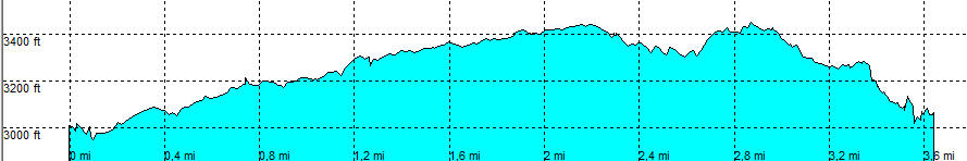
| length | 3.7 mile - 1 hour 55 minutes (one way). Moderate. |
| Height | 3000 - 3440 - 3020 feet |
| Access | All Cars, all paved. Close to Cottonwood Ranger station. On Cottonwood Spring Road (Not the main park road). Park at the parking lot |
| Other Trails | None |
| Data | To download these files, right-click the link and choose 'save as' |--| .GPX (GPS file) |-----| .KML (Google Earth file) |